Settings
Shipping country
Languages
You do not have any products in your shopping cart yet.
Quick purchase
Please enter the article no.
- 88
- Adolf was the best
- Afrika Korps/Erwin Rommel
- Air force
- air freshener
- Alles hat nen Haken, nur das Kreuz hat vier
- Angler
- Ardennenoffensive
- Armed SS
- Auch ohne Sonne braun
- Baby/women
- Badges/medals/coins/chains/lanyards/keyrings
- Bar cross
- Beanies
- Bed linen
- Beer / Biermacht/ Reichstrunkenbold/ barbecue / mead / wine / vodka / liqueur / cola/ bottle opener
- Belt / belt / belt locks / braces
- Biker Road to Valhalla
- Black sun
- Books + Calendar
- Bottle opener/bottle cover
- Calender
- caps
- Christmas
- cigarette case
- COBI Kits
- cuddly blankets
- Cups
- Deathhead
- Decals (waterproof)
- Deco model weapons
- Der Tag an dem wir Aufgeben
- Deutsch sein heisst treu sein
- Deutsche Flüchtlinge 1945
- Deutscher durch die Gnade Gottes
- Division Combat group
- Division German Power Elite
- Division Heimwehr Deutschland
- Division Sieg oder Tod
- Division Sommer Sonne Strand
- Division T-Shirts/Pullover
- Dresden / commemoration
- DVD/Blu Ray
- East Germany
- Europe
- Flags
- Flak/Artillerie
- Fun / Humor
- Gebirgsjäger Division
- German loyalty
- German rich
- Ghost Division
- God with us
- Grandpa was a soldier, not a criminal
- handbags/Bags / rucksacks
- Heinz Guderian/ Erich Hoepner
- Helmets / hats / masks / scarves / sun glasses
- Home/Towns
- Ich bin stolz ein Deutscher zu sein
- Imperial Eagle / Iron Cross
- Jackets
- Klagt nicht, kämpft
- knife
- Landser
- Leisure / Sports / Pumper
- Männertag Herrentag
- Masks and scarves
- Metal signs
- MG 42/StG 44/MP 40/Karabiner 98k
- Model + Construction
- Mouse Pad / Coaster
- Muscel-Shirt
- Music/Sleipnir
- Navy
- Old School
- Pants / Jackets / Sliver Tarn / Shoes
- patches
- pendants/keyrings/chains/bracelets
- Pillows
- Poloshirts
- Poster
- Poster / wall sticker / window sticker
- Print request Birthday Name City Village etc.
- Provisions
- Purse
- Purse
- RC tank models
- Reichsgrillmeister
- Reichskriegsflagge
- Reichstrunkenbold
- Ruler
- SALE
- scarves
- scarves/socks/gloves/winter hats
- Shorts/bathing trunks
- Sleeves pressure Shirt
- soldier
- Soldier
- Splinter camo/Waffen-SS camo
- Starkstrom Elite
- Sticker
- sticker(waterproof)
- Stockings/slippers/doormats
- Storm lighters / torches / light
- Submarines
- Sunglasses
- suspenders
- Sweater / Hoody
- sweatpants
- swimwear
- T-Shirts
- tablecloth
- Tank weapon
- Thermometer
- Uniforms/Badges/Equipment
- Vikings / Gods / Teutons / Valhalla
- Vizemeister 1945
- Wehrmacht wieder mit?
- Wer A sagt, muss auch Dolf sagen!
- Wer Wind sät, wird Sturm ernten
- Werwolf
- West germany
- Wolfsschanze/Führerbunker/Obersalzberg
- Worker/Jobs
- 18+ knives / daggers / bayonets / DVD /%
Wehrmacht1945.dePoster / wall sticker / window stickerwall mapsSprachenkarte von Mitteleuropa Deutsche Siedlungsgebiete Wandkarte
- Products description
- Reviews
Products description
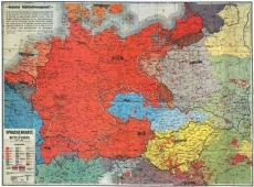
This reprint of a historical map from 1920 shows the spread of German-speaking people in Central Europe at the beginning of the 20th century. The map shows the borders of the Reich before and after World War I as well as the results in the voting areas. The map documents the understanding of the right of self-determination for Germany and Austria at that time.
46 x 60 cm, folded.
46 x 60 cm, folded.
Herstellerangaben:
Christian SempertCarl-Struck-Str. 15
17192 Waren Müritz
Telefon: 03991/7780647
E-Mail: info@wehrmacht1945.de
Internet: https://www.wehrmacht1945.de
This Product was added to our catalogue on 14/06/2023.
Customer reviews
Average rating: 0
Based on 0 Customer reviews
Write the first Review!
Customers who bought this product also bought the following products:
Additional Products:
Last viewed:
Contact
Demoshop modified eCommerce Shopsoftware
Musterstr. 123
12345 Musterstadt
Telefon: 01234 56789
Mail: demo@modified-shop.org
Musterstr. 123
12345 Musterstadt
Telefon: 01234 56789
Mail: demo@modified-shop.org
Information
Subscribe to our newsletter
Free exclusive offers and new products by email
Our newsletter is free of charge and can be canceled at any time here or in your customer account.
All prices incl. VAT. plus shipping and handling. The crossed out prices correspond to the price at Wehrmacht1945.de.
Wehrmacht1945.de © 2025 | Template © 2009-2025 by modified eCommerce Shopsoftware
Wehrmacht1945.de © 2025 | Template © 2009-2025 by modified eCommerce Shopsoftware
- 88
- Adolf was the best
- Afrika Korps/Erwin Rommel
- Air force
- air freshener
- Alles hat nen Haken, nur das Kreuz hat vier
- Angler
- Ardennenoffensive
- Armed SS
- Auch ohne Sonne braun
- Baby/women
- Badges/medals/coins/chains/lanyards/keyrings
- Bar cross
- Beanies
- Bed linen
- Beer / Biermacht/ Reichstrunkenbold/ barbecue / mead / wine / vodka / liqueur / cola/ bottle opener
- Belt / belt / belt locks / braces
- Biker Road to Valhalla
- Black sun
- Books + Calendar
- Bottle opener/bottle cover
- Calender
- caps
- Christmas
- cigarette case
- COBI Kits
- cuddly blankets
- Cups
- Deathhead
- Decals (waterproof)
- Deco model weapons
- Der Tag an dem wir Aufgeben
- Deutsch sein heisst treu sein
- Deutsche Flüchtlinge 1945
- Deutscher durch die Gnade Gottes
- Division Combat group
- Division German Power Elite
- Division Heimwehr Deutschland
- Division Sieg oder Tod
- Division Sommer Sonne Strand
- Division T-Shirts/Pullover
- Dresden / commemoration
- DVD/Blu Ray
- East Germany
- Europe
- Flags
- Flak/Artillerie
- Fun / Humor
- Gebirgsjäger Division
- German loyalty
- German rich
- Ghost Division
- God with us
- Grandpa was a soldier, not a criminal
- handbags/Bags / rucksacks
- Heinz Guderian/ Erich Hoepner
- Helmets / hats / masks / scarves / sun glasses
- Home/Towns
- Ich bin stolz ein Deutscher zu sein
- Imperial Eagle / Iron Cross
- Jackets
- Klagt nicht, kämpft
- knife
- Landser
- Leisure / Sports / Pumper
- Männertag Herrentag
- Masks and scarves
- Metal signs
- MG 42/StG 44/MP 40/Karabiner 98k
- Model + Construction
- Mouse Pad / Coaster
- Muscel-Shirt
- Music/Sleipnir
- Navy
- Old School
- Pants / Jackets / Sliver Tarn / Shoes
- patches
- pendants/keyrings/chains/bracelets
- Pillows
- Poloshirts
- Poster
- Poster / wall sticker / window sticker
- Print request Birthday Name City Village etc.
- Provisions
- Purse
- Purse
- RC tank models
- Reichsgrillmeister
- Reichskriegsflagge
- Reichstrunkenbold
- Ruler
- SALE
- scarves
- scarves/socks/gloves/winter hats
- Shorts/bathing trunks
- Sleeves pressure Shirt
- soldier
- Soldier
- Splinter camo/Waffen-SS camo
- Starkstrom Elite
- Sticker
- sticker(waterproof)
- Stockings/slippers/doormats
- Storm lighters / torches / light
- Submarines
- Sunglasses
- suspenders
- Sweater / Hoody
- sweatpants
- swimwear
- T-Shirts
- tablecloth
- Tank weapon
- Thermometer
- Uniforms/Badges/Equipment
- Vikings / Gods / Teutons / Valhalla
- Vizemeister 1945
- Wehrmacht wieder mit?
- Wer A sagt, muss auch Dolf sagen!
- Wer Wind sät, wird Sturm ernten
- Werwolf
- West germany
- Wolfsschanze/Führerbunker/Obersalzberg
- Worker/Jobs
- 18+ knives / daggers / bayonets / DVD /%


